
 |
| An image of the Holden Basin was captured by the Mars Express probe in April this year. (Image credit: ESA/DLR/FU Berlin) |
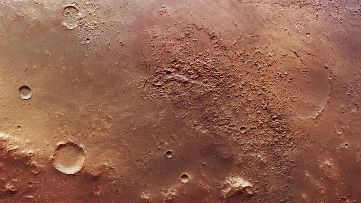
The European Space Agency's Mars Express mission obtained stunning photographs of Mars' Holden Basin, a critical location in the continuing hunt for life on the Red Planet. The photographs, as well as future analysis of the area, may help explain how water originally traveled over the Martian surface. The close-up view of the Holden Basin taken by Mars Express' High-Resolution Stereo Camera (HRSC) on April 24, 2022, reveals geological characteristics of the ancient water reservoir near the almost 95-mile-wide (150-kilometer) Holden Crater.
The Holden Basin is one of the channels and sinks that make up the Uzboi-Ladon-Morava (ULM) outflow system in Mars' southern hemisphere. This system has become a key target for Mars orbiters such as Mars Express because scientists believe it formerly drained up to 9% of Mars's water. Liquid water would have flowed via channels that drain into the Argyre Planitia before Mars lost its water roughly 4 billion years ago, probably due to the Martian atmosphere being stripped by intense solar radiation, allowing water vapor to 'leak' into space.
Water would have flowed from this 1,100-mile-wide (1,770-kilometer) plain into the valley known as the 'Uzboi Vallis,' through the area now defined by the Holden Crater, which was formed later in the planet's history. Water would have accumulated in the Holden Basin before flowing through Ladon Valles, an ancient river valley system that leads to the Ladon Basin, which is 274 miles (440 km) wide. The new view shows a prominent crater south of the basin, as well as basin walls that gradually descend to a depth of about 5,000 feet (1,500 meters) below the surrounding Martian surface.
Meanwhile, the Holden Basin's northeastern edge depicts where water would have flowed from this reservoir to the Ladon Valles. Scarring and rugged topography can be seen in the picture, which was most likely caused by the melting of water ice under the Martian surface. According to the European Space Agency (ESA), experience with our own planet reveals that water and life go hand in hand. Scientists want to know if the same was true for Mars billions of years ago.
The soils of Ladon Valles and Holden Basin are rich in phyllosilicate, a kind of mineral that comprises clays formed by the interaction of rock and water and connected to the origins of life on Earth. Phyllosilicates are found in stratified deposits in these areas and might have served as a reaction center for organic molecules, the building blocks of terrestrial life. This is why scientists are so interested in the subject. Holden Crater was most likely formed as a result of an ancient asteroid hit, when debris ejected by the impact fell back to the planet's surface and filled the older Holden Basin, which had formed as a result of an earlier collision in the planet's history.
Because there is no indication of water flowing through the Holden Crater in the past, geologists assume it developed after the ULM system dried out. The Holden Crater was considered as a landing location for the Curiosity and Perseverance rovers due to its geological significance and potential to house evidence of ancient life, but it was defeated by Gale Crater and Jezero Crater, respectively.
Mars Express, which has been photographing the Martian surface and atmosphere from orbit since 2003, is now ensuring that the area is thoroughly examined. Previously discovered ridges and grooves sculpted by Martian winds, impact craters, and ancient rivers, as well as petrified lava lakes and volcanoes, were all visible in photos of the Holden Basin.


0 Comments