
Bruce Pascoe's Dark Emu is in the news again, with the publication of a new book critiquing Pascoe's arguments. Dark Emu builds on an earlier, less-known work by archaeologist Rupert Gerritsen, who argued a number of regions across Australia should be considered centers of Aboriginal agriculture.
Historians Billy Griffiths and Lynette Russell, and now anthropologist Peter Sutton and archaeologist Keryn Walshe, have argued Pascoe has fallen into a trap of privileging the language of agriculture above hunter-gatherer socioeconomic systems.
We have been working in a landscape that provides an important test of the Dark Emu hypothesis. In partnership with the Mithaka Aboriginal Corporation, which occupies the Channel Country in Central Australia, we have begun investigating Aboriginal settlement sites, pit dwelling huts (known as gunyahs), and quarries.
Our landscape study, published in the journal Antiquity, has found over 140 quarry sites, where rock was excavated to produce seed grinding stones. We have also developed a method to locate traces of long-lost village sites.
Were First Australians farmers or hunter-gatherers? Contemporary archaeological research suggests it's not such a simple dichotomy. Understanding the Mithaka food production system may well tell us whether such terms are a good fit for defining socio-economic networks in Aboriginal Australia.
The Channel Country spreads across the Lake Eyre Basin, found in parts of Queensland, Northern Territory, and South Australia. It is the world's last unregulated desert channel system (meaning there has been no intensive irrigation or damming) and one of Australia's richest beef cattle areas. The meandering channels are fed infrequently by monsoonal rains from the north, which transform large sections of the desert into a lush, green landscape.
In 2017, Mithaka Elder George Gorringe led a small expedition to an ancient clay-pan (an old lake bed) where one of us had recorded a burial site some years before. But the plan dramatically changed when monsoonal rains in the tropics flooded the land, diverting the expedition from north to the south.
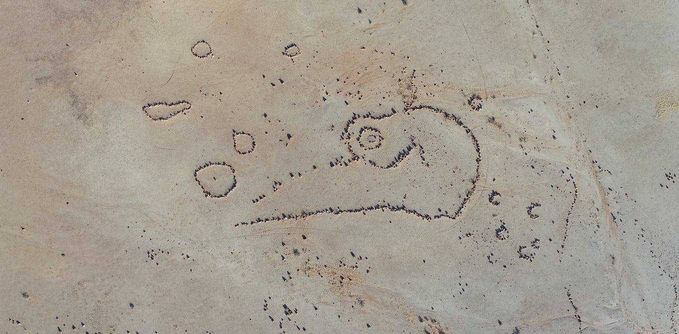
The extensive flood plains turned green as life-giving water irrigated native grasses and other plant species. George led the expedition to a series of sites he knew about from his father, Bill Gorringe, and from his previous work on numerous stations and as a council road works foreman. They included massive sandstone quarry sites, stone arrangements, and the remains of Aboriginal pit dwelling huts (gunyahs): excavated structures with branches constructed over the top.
This largely intact archaeological landscape has the largest seed grinding quarry sites in the country. Archaeologist Mike Smith has discussed the importance of seed grinding implements for the economy of this region. Grinding stones were used to process native grasses and produce a form of bread. Axes scattered across the area also indicate trade with the Kalkadoon people from the Mount Isa quarries in the north.
It became clear from this first trip that this extraordinary landscape had enormous potential to investigate questions relating to Aboriginal trade and exchange, settlement systems, and food production.
When Europeans first stumbled across this landscape in the 1870s, as historian Ray Kerkhove discovered in the archives, they observed civilized blacks living in villages and maintaining intensive fishing industries. In 1871, for example, a sub-inspector of the Queensland Native Police, James Gilmour, came across a village of 103 huts at the southern end of Thunderpurty lagoon while looking for evidence of the missing explorer Ludwig Leichardt.
History also records practices in the region including cultivation associated with ceremony, and fish trap and storage systems equating to aquaculture.
This landscape was very different from other areas in arid Australia well documented by historians and modern anthropologists. Unlike the more marginal desert environments in the center, Channel Country could support large numbers of cattle. This indicated it was also able to support larger populations of Aboriginal people.
Higher population numbers and the economic value of Channel Country to European pastoralists resulted in significant conflict, devastating the traditional Mithaka economic system. Archaeology thus plays a prominent role in reconstructing the past here.
Some cultural stories from Mithaka country were documented from the early 1900s by amateur ethnographer Alice Duncan Kemp, who lived on Mooraberrie Station until the late 1920s. An innovative researcher trusted and respected by senior Aboriginal informants, Alice provides an important account of the complexity of the Mithaka social system, tying it into the landscape.
We have started to document this through cultural mapping, with the Duncan Kemp family. The Mithaka have designed a framework to help guide researchers in ethically telling the story of their landscape.
We are now using drones to record in 3D enormous quarries, which appear to be on an industrial scale. Archaeologist Doug William's excavations, supported by the work of dating expert Justine Kemp, show quarrying at one site may have begun more than 2,000 years ago.
If this is the case, the transcontinental trade system referred to by pioneering Australian archaeologist John Mulvaney as the "Chain of Connection" (extending from the Gulf of Carpentaria to the Flinders Ranges) may be at least twice as old as previously thought.
Could this trading system have played a role in the development of more intensified quarrying activity and more sedentary settlement systems? We are working on understanding the relationship between archaeology and this remarkable social and economic network.
We have investigated eroding burial sites to see if the remains of the Mithaka ancestors themselves can provide clues to the past.
Limited analysis so far provides evidence of bio-mechanical stress to the upper limbs, likely a result of intense seed grinding. By studying geochemical signatures (isotopes) in human teeth we hope to establish if people maintained a large foraging range or were more sedentary, living in more restricted clan boundaries.
We have built a background isotopic map to help us understand people's mobility in the past. When people live in a landscape they ingest its isotope signature. Investigating the mobility of the Mithaka populations through isotopes will be an important test of whether documented village sites were seasonal or permanent.
One logical place to start an investigation of past food production systems is to look where people once lived. Early historic accounts record large village sites, so we have developed a methodology to find these places.
Geoarchaeologist Kelsey Lowe has used a magnetometer, designed to detect magnetic anomalies beneath the earth's surface, to search for signs of ancient houses (gunyahs). By investigating standing gunyahs, dating back to the 19th century, we have detected distinct magnetic signatures for these dwellings.
Archaeobotanists Nathan Wright and Andrew Fairbairn are carefully sifting through deposits to identify wood charcoal and evidence of plant use. Expertise in recovering not only ancient seeds and plant remains, but importantly, burnt plant remains in ancient fireplaces will play a key role in telling the past economic story.
Zooarchaeologist Tiina Manne has begun a study of recovered animal bones, which also include the inner ears (otoliths) of fish (yellowbelly). These may provide insights into past aquaculture systems hinted at in the historical record.
We have started to document fish traps in the landscape. And geoarchaeologist Mike Morley has taken molds of excavation pits to analyze microscopic evidence of hut floors and the areas in front of the gunyahs.
Botanist Jen Silcock is working with Mithaka Elders to understand more about plant use. Important food and medicinal plants such as native millet, sorghum, and different species of desert shrubs will be investigated by plant geneticist Robert Henry. He will see if we can find evidence of people deliberately moving plants and identify traits of domestication within the genomes of important species.
Palynologist Patrick Moss has taken cores from lake sediments to recover ancient pollen sequences associated with known village site locations. He will examine how the environment changes over time and whether he can detect any shifts in pollen, which may represent more intensified use of plants.
Historian Tom Griffiths, meanwhile, has begun to investigate the history of conflict in the landscape, as Europeans and Native Police raged war with the traditional owners of Mithaka country in the late 1800s.
This is important to understand because elsewhere in the country, archaeologists have suggested the development of village settlements may have been a response to colonial violence, rather than representing a traditional settlement system.
For one of us (Michael), the ideas generated through Gerritsen's research and Pascoe's popularized account have inspired and stimulated a different way of thinking about Aboriginal food production systems, and how we might investigate an archaeological record for Aboriginal village settlements.
And for the other (Josh), Dark Emu provides a different account of the Aboriginal past, written by an Aboriginal person outside of the academy, which challenges us to think differently about how we might define Aboriginal people. Josh believes it is up to archaeologists now to test Pascoe's hypothesis.
Hidden in the Mithaka landscape is a cultural narrative with great power to tell new and important stories. Multidisciplinary research involving traditional owner knowledge, even when fragmented by the ravages of past conflict and displacement, can re-energize landscapes.
It can provide a context for a richer, more nuanced, and more comprehensive understanding of ancient Australia, creating a space for cultural learning, education, and respect.


0 Comments